UTM GRID AND 2013 MAGNETIC NORTH DECLINATION AT CENTER OF SHEET U.S. National Grid 100,000-m Square ID
CU Grid Zone Designation
13S
Diablo Canyon
69
70
3
3
SCALE 1:24 000
1
0.5
1000
500
0
1000
0.5 2000
0
KILOMETERS
1
2
0
METERS 0
1000
2000
3000
4000
MILES FEET
5000
8000
8400
Encino 368 Canyon
× MN
0° 49´ 15 MILS
27' 30"
8200
8200
67
'
6000
7000
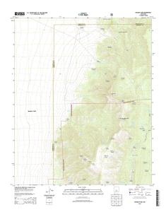
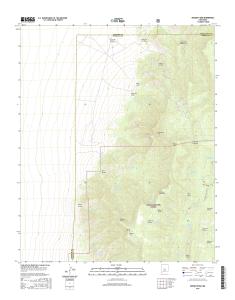
CONTOUR INTERVAL 40 FEET NORTH AMERICAN VERTICAL DATUM OF 1988 This map was produced to conform with the National Geospatial Program US Topo Product Standard, 2011. A metadata file associated with this product is draft version 0.6.15
8000
9000
25'
8800
Diablo Spring
'
72
71
1 10000
7600
Cañon del Venado
Expressway
34° 45'
73000mE
ROAD 7CLASSIFICATION 8 00
Local Connector Local Road
Ramp
QUADRANGLE LOCATION
Hubbell Spring
Mount Washington
Escabosa
Los Lunas SE
Bosque Peak
Tajique
Tome NE
Capilla Peak
Torreon
ADJOINING 7.5' QUADRANGLES
106° 22' 30"
3
Secondary Hwy
NEW MEXICO
47000mN
38
7600
Diablo Canyon
3
3
48
38
Cañon del Venado
55
9200
Encino Canyon
3
Cañon de Novillo 7600
7800
8600
7600
7600
6400 5800
This map is not a legal document. Boundaries may be generalized for this map scale. Private lands within government reservations may not be shown. Obtain permission before entering private lands.
66
3
'
8200
9400
8000
0 750
North American Datum of 1983 (NAD83) World Geodetic System of 1984 (WGS84). Projection and 1 000-meter grid: Universal Transverse Mercator, Zone 13S 10 000-foot ticks: New Mexico Coordinate System of 1983 (central zone)
Encino Trailhead
8000
0 750
8000
Produced by the United States Geological Survey
65
TA J IQUE LOO P
RD
8400
'
8200
9400
Bosque Peak
Bosque Trailhead
Cave Spring
4WD
X W Interstate Route
. US Route /
J FS Primary Route
K
FS Passenger Route
H State Route
Check with local Forest Service unit for current travel conditions and restrictions.
BOSQUE PEAK, NM 2013
FS High
L Clearance Route
7 6 4 3 0 1 6 3 8 2 6 8 7 NSN. NGA REF NO. U S G S X 2 4 K 4 9 2 2
26 nov. 2013 - CIBOLA NATIONAL FOREST. C. IB. O. L. A. N. A. T ... Meadow Lake. Cañon de los Moyos .... with limited Forest Service updates, 2013. Names.
Eureka. Mesa. San Pedro. Peaks. San Pedro. Peaks. San Pedro. Mountains. Puertecito de las Perchas ... 8 Seven Springs. 2 Gallina. 3 Arroyo Del Agua. 4 Cuba.
Río San. R ío de las Vacas. Río Guaonica. Río Viví. R ío. Grande de Arecibo. Río ... Jordan. Lago. Adjuntas. PO. Adjuntas. Quebrada. La Mocha. Quebrada.
Haystac. Mounta. D o g. M o u n ta in s. Dog. Spring. Ranch. D eer. Flat. Eagle. Mountain. Campbell. Well. Sentinel. Butte. Dog. Mountains. Pierce. Peak. Corner.
Rio Grande. Rio Grande. Rio Grande. R io. G ra n d e. Rio Grande. R io. G rande ... Canyon. Quinn. Creek. Gettysburg. Peak. McCutchen. Ranch. Candelaria. 13.
S 220TH ST. RENTON AVE S. W JAMES ST. S 127T ..... E JAMES ST. SW 34TH ST. SW 7TH ST. 8. 4. T. H ..... 1 Seattle South. 8 Black Diamond. 2 Mercer Island.
84TH ST SE. 86TH ST SE. 84TH ST SE. 8. 9. T. 83RD ST SE. 8. 6. T. H. A. V. E. S. E. 88TH ST SE. 86TH ST SE. 88TH ST SE. C. R. -3. M a p le. R iv er. Maple River. S. F o rk. M a p le. R iv e r. Maple River. Monango. Boynton. 30'. 98°. 46°. 30". 46°. 3
River. Rush River. Lower Br Rush River. Rush River. M aple River. Maple River. R u sh. R iver. Mapleton. Cem. Newman. Mapleton. Prosper. 30". 00'. 97°. 30".
Bull Tank. North Tank. Green. Tank. Continental Tank. Mangas Cr. L a r g o. C r. Caballeriza. Tank. Hell Hole. Tank. Largo. Canyon Tank. El Caso. Lake. Gooseberry. Pit. Indio. Canyon Tank. Jacobs. Camp Tank. San Antone. Tank. Slaughter. Mesa Tank. Ca
Arkansas River. A rkansas River. A rk a n sas River. A rk a n sa s. R iv e r. Ellinwood. PO. Grove Park Golf. Course. Saint. Josephs Cem. Big Salt. Marsh. Alden.