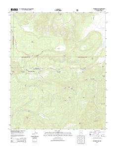
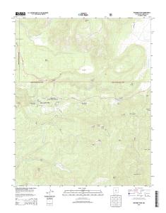
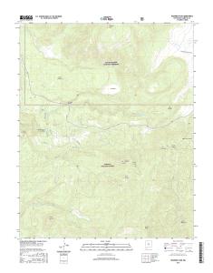
USGS 7.5-minute image map for Redondo Peak ... - The National Map
SANTA FE. NATIONAL FOREST pence. Hot pring auley pring. Jemez. Falls. La Jara Cr .... 1 000-meter grid: Universal Transverse Mercator, Zone 13S. Produced ...
UTM GRID AND 2013 MAGNETIC NORTH DECLINATION AT CENTER OF SHEET U.S. National Grid 100,000-m Square ID
CV Grid Zone Designation
13S
0.5
0
1000
500
0
0
9000
9000 840 0
8600
8200
8600
8400
9000
8800
7800
7800 760 0
74 00
9000
1
1000
0.5 2000
3000
3
SCALE 1:24 000 8200
60
32' 30"
8400
1
2
METERS 0
1000
2000
MILES FEET
5000
6000
7000
CONTOUR INTERVAL 40 FEET NORTH AMERICAN VERTICAL DATUM OF 1988 This map was produced to conform with the National Geospatial Program US Topo Product Standard, 2011. A metadata file associated with this product is draft version 0.6.15
8000
9000
NEW MEXICO
64000mE
8000
3
QUADRANGLE LOCATION
Seven Springs
Valle San Antonio
Valle Toledo
Jemez Springs
Redondo Peak
Bland
Ponderosa
Bear Springs Peak
Cañada
ADJOINING 7.5' QUADRANGLES
8600
ROAD CLASSIFICATION
Expressway
Local Connector
Ramp
4WD
X W Interstate Route
. US Route /
J FS Primary Route
K
FS Passenger Route
H State Route
REDONDO PEAK, NM 2013
FS High
L Clearance Route
Check with local Forest Service unit for current travel conditions and restrictions.
35° 45'
106° 30'
Local Road
Secondary Hwy
1 10000
63
3
3
8800
KILOMETERS
4000
62
61
3
7 6 4 3 0 1 6 3 8 3 9 7 2 NSN. NGA REF NO. U S G S X 2 4 K 3 7 4 9 3
This map is not a legal document. Boundaries may be generalized for this map scale. Private lands within government reservations may not be shown. Obtain permission before entering private lands.
0 860
8200
55
00 88
9000
9100
8800
Produced by the United States Geological Survey North American Datum of 1983 (NAD83) World Geodetic System of 1984 (WGS84). Projection and 1 000-meter grid: Universal Transverse Mercator, Zone 13S 10 000-foot ticks: New Mexico Coordinate System of 1983 (central zone)
-280. -10. -281. -280. -270. -10. -281. -270. ¬«4. ¬«4. ¬«4. ¬«4. JEMEZ FALLS RD. FOREST RD. 10. VALLECITOS RD. FORES. T. R. D. 1. 3. 4. H. O. VEN. W. E.
for current travel conditions and restrictions. FS Primary Route. FS High. Clearance Route. FS Passenger. Route. J. K. L. Interstate Route. State Route. US Route.
Eureka. Mesa. San Pedro. Peaks. San Pedro. Peaks. San Pedro. Mountains. Puertecito de las Perchas ... 8 Seven Springs. 2 Gallina. 3 Arroyo Del Agua. 4 Cuba.
Río San. R ío de las Vacas. Río Guaonica. Río Viví. R ío. Grande de Arecibo. Río ... Jordan. Lago. Adjuntas. PO. Adjuntas. Quebrada. La Mocha. Quebrada.
Haystac. Mounta. D o g. M o u n ta in s. Dog. Spring. Ranch. D eer. Flat. Eagle. Mountain. Campbell. Well. Sentinel. Butte. Dog. Mountains. Pierce. Peak. Corner.
Rio Grande. Rio Grande. Rio Grande. R io. G ra n d e. Rio Grande. R io. G rande ... Canyon. Quinn. Creek. Gettysburg. Peak. McCutchen. Ranch. Candelaria. 13.
S 220TH ST. RENTON AVE S. W JAMES ST. S 127T ..... E JAMES ST. SW 34TH ST. SW 7TH ST. 8. 4. T. H ..... 1 Seattle South. 8 Black Diamond. 2 Mercer Island.
84TH ST SE. 86TH ST SE. 84TH ST SE. 8. 9. T. 83RD ST SE. 8. 6. T. H. A. V. E. S. E. 88TH ST SE. 86TH ST SE. 88TH ST SE. C. R. -3. M a p le. R iv er. Maple River. S. F o rk. M a p le. R iv e r. Maple River. Monango. Boynton. 30'. 98°. 46°. 30". 46°. 3
River. Rush River. Lower Br Rush River. Rush River. M aple River. Maple River. R u sh. R iver. Mapleton. Cem. Newman. Mapleton. Prosper. 30". 00'. 97°. 30".
Bull Tank. North Tank. Green. Tank. Continental Tank. Mangas Cr. L a r g o. C r. Caballeriza. Tank. Hell Hole. Tank. Largo. Canyon Tank. El Caso. Lake. Gooseberry. Pit. Indio. Canyon Tank. Jacobs. Camp Tank. San Antone. Tank. Slaughter. Mesa Tank. Ca