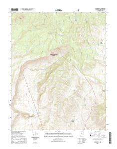
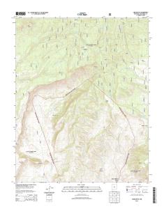
USGS 7.5-minute image map for Canjilon SE ... - The National Map
O. N. M. E. SA. CARSON NATIONAL. FOREST. Ojito de las. Cienaguitas. Ojito. Carrizo. Ojito. Sastras. Ojito. Soldados. Ojito del. Comanche o de Com ales. A rro.
1000 UTM GRID AND 2017 MAGNETIC NORTH DECLINATION AT CENTER OF SHEET U.S. National Grid 100,000-m Square ID
CA Grid Zone Designation
13S
0.5
1000
500
0
1000
0.5 2000
6700
770 0
7800
77 00
70 00
7700
6300
0
KILOMETERS
1
2
0
METERS 0
1000
2000
3000
4000
MILES FEET
5000
6000
7000
CONTOUR INTERVAL 20 FEET NORTH AMERICAN VERTICAL DATUM OF 1988 This map was produced to conform with the National Geospatial Program US Topo Product Standard, 2011. A metadata file associated with this product is draft version 0.6.19
8000
9000
ro
630 0
yo
Ho
85 Madera
3
63 00
nd
o
Cañon
2
4 6
3
Ramp
5 7
8
ADJOINING QUADRANGLES
1 2 3 4 5 6 7 8
Canjilon Mogote Peak Valle Grande Peak Ghost Ranch El Rito Canones Abiquiu Medanales
7000
6900
106°15'
6700
ROAD CLASSIFICATION
X W Interstate Route
« ª 1
670 0
36°15'
87000mE
Secondary Hwy
QUADRANGLE LOCATION
6400 3
Expressway
NEW MEXICO
1 10000
86
3
00 65
0 640
00 67
64 00
6500 66 00
1
Ar
00 64
13000mN
40
FS Primary Route
Local Connector
Local Road 4WD
. US Route /
FS Passenger Route
H State Route
FS High Clearance Route
Check with local Forest Service unit for current travel conditions and restrictions.
CANJILON SE, NM 2017
7 6 4 3 0 1 6 3 8 2 7 5 5 NSN. NGA REF NO. U S G S X 2 4 K 7 0 5 9
1
6800
6700
6500
67 00
680 0
SCALE 1:24 000
6500
17'30"
7900
*7643016382755*
GN
8° 38´ 154 MILS
83
3
65 00
0 710
690 0
▬
0° 47´ 14 MILS
Ù
82
6500
640 0
3
^ MN
780 0 68 00
68 00
650 0 6600
6600
65 00
640 0
6900
81
3
7900
This map is not a legal document. Boundaries may be generalized for this map scale. Private lands within government reservations may not be shown. Obtain permission before entering private lands. Imagery.............................................NAIP, October 2014 Roads................................ U.S. Census Bureau, 2015 - 2016 Roads within US Forest Service Lands.............FSTopo Data with limited Forest Service updates, 2012 - 2016 Names...............................................................GNIS, 2016 Hydrography....................National Hydrography Dataset, 2014 Contours............................National Elevation Dataset, 2000 Boundaries............Multiple sources; see metadata file 1972 - 2016 Public Land Survey System..................................BLM, 2016 Wetlands.........FWS National Wetlands Inventory 1977 - 2014
20'
Sierra
14 Negra
00 72
00 68
Geological700Survey
6 North American Datum of 1983 (NAD83) World Geodetic System of 1984 (WGS84). Projection and 1 000-meter grid: Universal Transverse Mercator, Zone 13S 10 000-foot ticks: New Mexico Coordinate System of 1983 (central zone)
This map was produced to conform with the. National Geospatial Program US Topo ... FSTopo Data with limited Forest Service updates, 2012 - 2016. Names.
Eureka. Mesa. San Pedro. Peaks. San Pedro. Peaks. San Pedro. Mountains. Puertecito de las Perchas ... 8 Seven Springs. 2 Gallina. 3 Arroyo Del Agua. 4 Cuba.
Río San. R ío de las Vacas. Río Guaonica. Río Viví. R ío. Grande de Arecibo. Río ... Jordan. Lago. Adjuntas. PO. Adjuntas. Quebrada. La Mocha. Quebrada.
Haystac. Mounta. D o g. M o u n ta in s. Dog. Spring. Ranch. D eer. Flat. Eagle. Mountain. Campbell. Well. Sentinel. Butte. Dog. Mountains. Pierce. Peak. Corner.
Rio Grande. Rio Grande. Rio Grande. R io. G ra n d e. Rio Grande. R io. G rande ... Canyon. Quinn. Creek. Gettysburg. Peak. McCutchen. Ranch. Candelaria. 13.
S 220TH ST. RENTON AVE S. W JAMES ST. S 127T ..... E JAMES ST. SW 34TH ST. SW 7TH ST. 8. 4. T. H ..... 1 Seattle South. 8 Black Diamond. 2 Mercer Island.
84TH ST SE. 86TH ST SE. 84TH ST SE. 8. 9. T. 83RD ST SE. 8. 6. T. H. A. V. E. S. E. 88TH ST SE. 86TH ST SE. 88TH ST SE. C. R. -3. M a p le. R iv er. Maple River. S. F o rk. M a p le. R iv e r. Maple River. Monango. Boynton. 30'. 98°. 46°. 30". 46°. 3
River. Rush River. Lower Br Rush River. Rush River. M aple River. Maple River. R u sh. R iver. Mapleton. Cem. Newman. Mapleton. Prosper. 30". 00'. 97°. 30".
Bull Tank. North Tank. Green. Tank. Continental Tank. Mangas Cr. L a r g o. C r. Caballeriza. Tank. Hell Hole. Tank. Largo. Canyon Tank. El Caso. Lake. Gooseberry. Pit. Indio. Canyon Tank. Jacobs. Camp Tank. San Antone. Tank. Slaughter. Mesa Tank. Ca